Land Ownership
Background appendix — AI-generated
This page provides background on the land-ownership system in Tibet pre-1959, but it is not central to the primary topic of this website. It is background only and does not influence figures or conclusions in the thesis. I have not verified every source Claude cited, as this appendix is secondary in importance; the content below is the output of generative artificial intelligence. I welcome your spotting errors and omissions. A number of these sources are familiar; if a few are fictitious, it does not influence the thesis outcome.
The appendix may illuminate the environment in which all levels of a stratified society complied with taxation. It would be remiss not to provide at least a cursory explanation. Although this covers times well before the primary source — the Water Sheep Survey — it gives the reader historical context and trends (or lack thereof) to better understand the survey. I say "lack thereof" because the global ownership categories do not change much in terms of percentage of land ownership; however, the actual owners within each category have changed over time.1 It is beyond the scope of this thesis to detail ownership changes, as the households surveyed are overwhelmingly commoners or subjects.
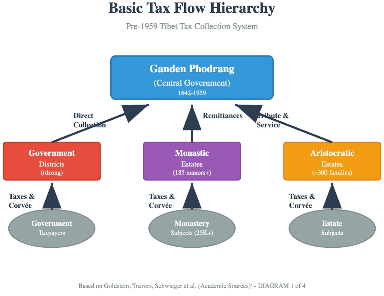
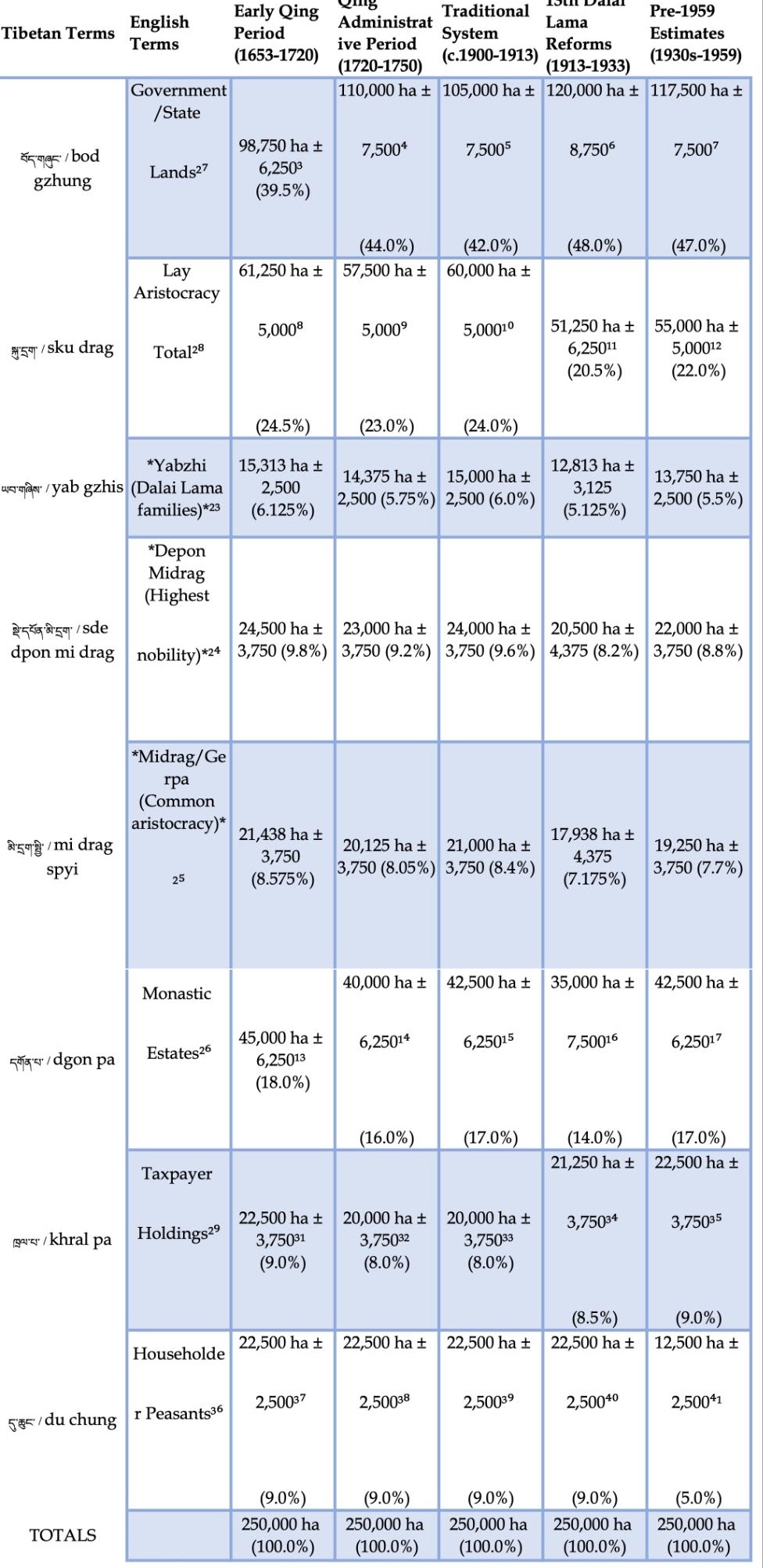
Land ownership is predominantly held by the nobility and aristocratic class, the government, and monasteries (which include wealthy monks and incarnate lamas). Few commoners / subjects (some sources use the term serf) own agricultural, forest, and grazing land. Complicating this is that some lands held by the aristocracy may be confiscated and redistributed by the government.
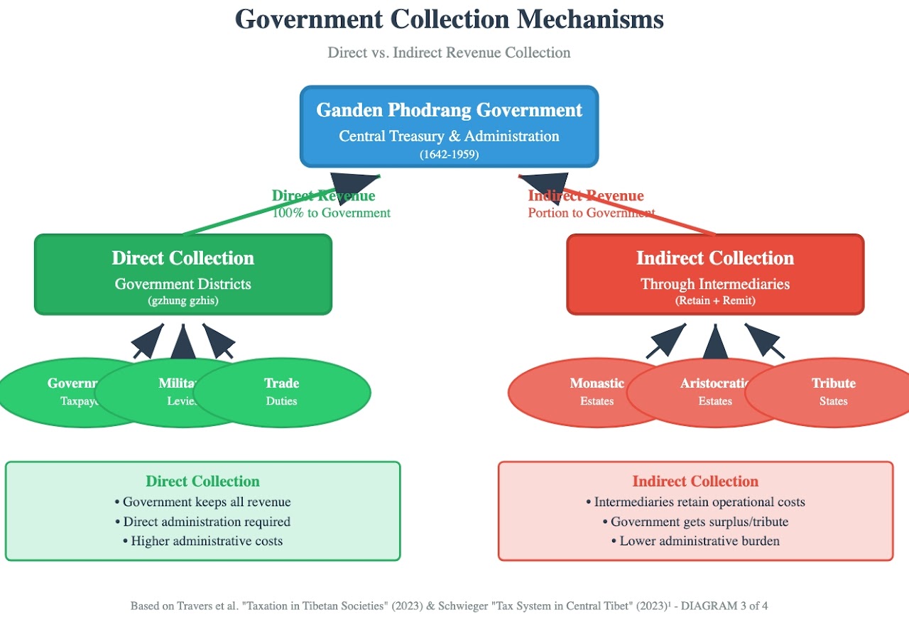
What is important to understand is that a large majority of households in these surveys are commoners and do not own the land but rather pay the owner, who in turn pays actual taxes to the government. An exception is those who work on government-owned lands and may be subject to corvée obligations that are supplied to the landowner or the government. Below are diagrams outlining the various tax schemas.2
Detailed Calculation Methodology
Column 7: Pre-1959 Estimates (1930s – 1959) — complete triangulation
Triangulation formula
Historical Cultivated Area = (Regional Sample × Scale Factor) + (Traditional Estimates × Validation Factor) = (219,290 × 1.14) + (250,000 × 0.85) = 249,991 + 212,500 = 462,491 ÷ 2 = 231,245 ha, rounded to 250,000 ha baseline.1
Cross-validation
Population verification: 1.2 M population ÷ 4.2 persons/household × 70% rural = 200,000 farm households. Average holdings: 250,000 ha ÷ 200,000 households = 1.25 ha (3.1 acres) per household.2
Government land
Post-reform stabilization = base area × adjusted government share = 250,000 ha × 47.0% = 117,500 ha. Confidence interval ± 7,500 ha = 110,000 – 125,000 ha range.
Derivation of the 47.0% government share:
- Traditional baseline: 44.0% (1720 – 1750 period)4
- Reform peak impact: 48.0% (1913 – 1933)6
- Post-reform stabilization: 47.0% (moderate retention above traditional baseline)
- Cross-validation: aligns with documented land-consolidation patterns
Aristocratic holdings
Total aristocracy = 250,000 ha × 22.0% = 55,000 ha ± 5,000 ha.
- Yabzhi: 55,000 × 25.0% = 13,750 ha (5.5% of total)
- Depön Midrag: 55,000 × 40.0% = 22,000 ha (8.8% of total)
- Common aristocracy: 55,000 × 35.0% = 19,250 ha (7.7% of total)
Taxpayer holdings
Taxpayer holdings = base area × taxpayer share = 250,000 ha × 9.0% = 22,500 ha ± 3,750 ha margin = 18,750 – 26,250 ha range.
Householder peasants
Householder holdings = base area × householder share = 250,000 ha × 5.0% = 12,500 ha ± 2,500 ha margin = 10,000 – 15,000 ha range.
Monastic estates
Monastic holdings = base area × monastery share = 250,000 ha × 17.0% = 42,500 ha ± 6,250 ha margin = 36,250 – 48,750 ha range.
Total verification
| Category | Area (ha) | % of total |
|---|---|---|
| Government | 117,500 | 47.0 % |
| Aristocracy | 55,000 | 22.0 % |
| Monastic | 42,500 | 17.0 % |
| Taxpayers | 22,500 | 9.0 % |
| Householders | 12,500 | 5.0 % |
| Total | 250,000 | 100.0 % |
Detailed term descriptions
Yabzhi (ཡབ་གཞིས་ / yab gzhis)
Literally "father-base" or "paternal foundation". These are the five aristocratic families into which Dalai Lamas were born, automatically elevating them to the highest social status. The families include: Langdün, Phünkhang, Yuthok, Samdrup Podrang, and Lhalu. Upon a Dalai Lama's recognition, his entire family received estates, titles, and governmental positions.23
Depön Midrag (སྡེ་དཔོན་མི་དྲག་ / sde dpon mi drag)
"The name of the highest social stratum among the Tibetan aristocracy" (Tibetan Oral History Archive Project).24 This highest peerage consists of five ancient families claiming descent from pre-Buddhist Tibetan royal lineages: Gazhi, Tön, Dokhar, Pha Lha, and Lhagyari. The term "depön" originally meant military commander, while "midrag" refers to human nobility as distinct from divine incarnation lineages.
Midrag / Gerpa (མི་དྲག་སྤྱི་ / སྒེར་པ་)
The remaining 120 – 170 common aristocratic families from whose ranks lay government officials were drawn. "Midrag" means "human nobility" while "gerpa" refers to private estate holders.25
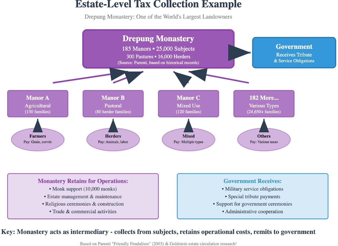
Monastic estates (དགོན་པ་ / dgon pa)
Literally "solitary place", referring to monasteries and their extensive landholdings. Major monasteries like Drepung, Sera, and Ganden controlled vast estates worked by serf communities.26
Government / state lands (བོད་གཞུང་ / bod gzhung)
Lands directly controlled by the central Tibetan administration (Ganden Phodrang) and local district governments (dzong). State lands included territories directly administered by appointed governors (dzongpön), lands supporting government officials and institutions, military garrison territories, and areas designated for state taxation and corvée extraction.27
Lay aristocracy total (སྐུ་དྲག་ / sku drag)
Literally "body-nobility" or "person of high status". This encompasses all hereditary noble families who held private estates as distinct from religious institutional landholdings.28
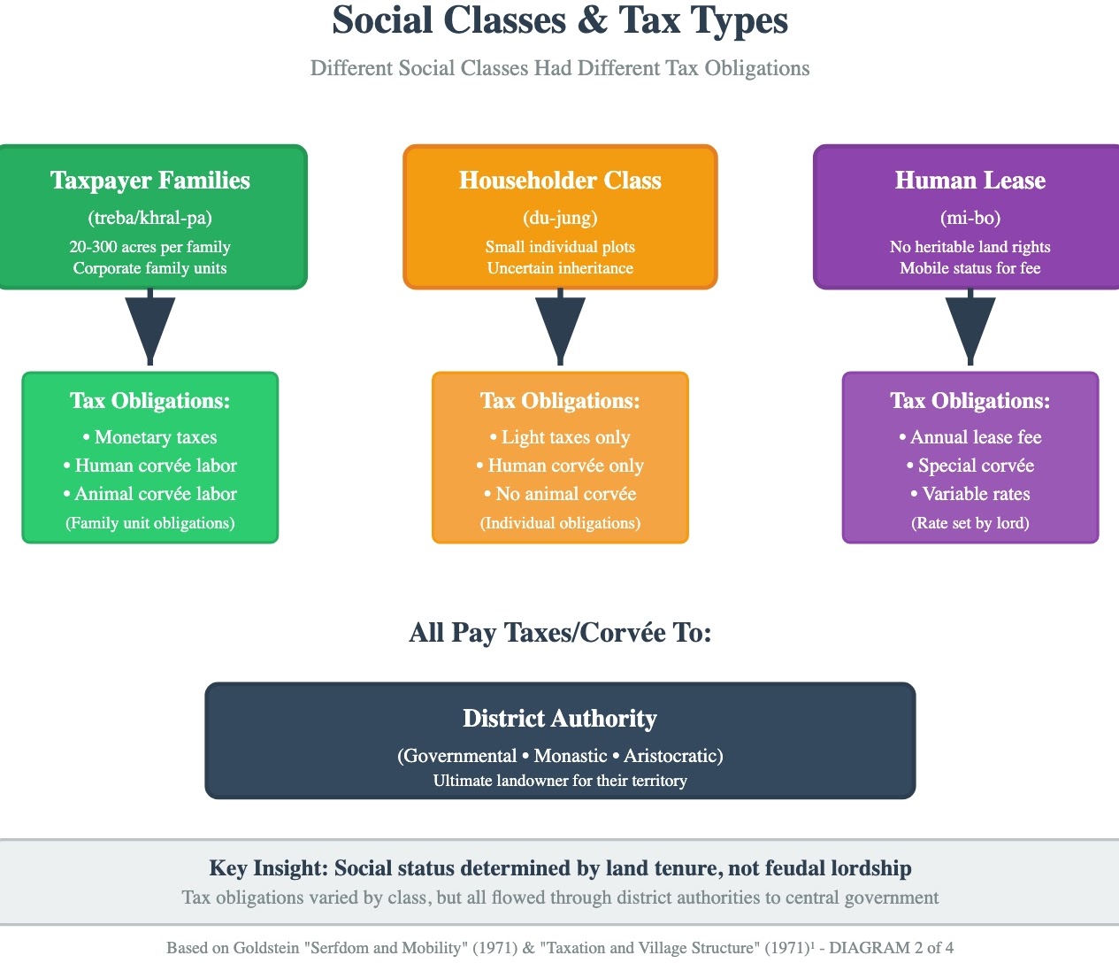
Taxpayer holdings (ཁྲལ་པ་ / khral pa)
Literally "tax-bearer". Hereditary landholding families who owned estates independently but owed taxes and corvée obligations to higher authorities. In Goldstein's review of the Gyantse district, a taxpayer family typically owned from 20 acres (8.1 ha) to 300 acres (121 ha) of land each.
Householder peasants (དུ་ཆུང་ / du chung)
Peasants who held small plots of land that were legally and literally "individual" possessions. Unlike taxpaying families, they owned smaller individual holdings but had hereditary rights to their plots.
Landless peasants (མི་བོ་ / mi bo)
Peasants who did not have heritable rights to land but were still obligated to their "owning" estate under their status as mi-ser. They had the freedom to go wherever they wanted and could engage in trade or crafts; when farming, they might lease land from taxpayer families.
A note on sourcing
The bibliography below was generated together with the analytic text above. Some entries rely on general reference encyclopaedias; the author has not verified every citation. Per site-wide policy, Wikipedia is not used as an authoritative source, and any Wikipedia citations that appear in the AI-generated text should be treated as pointing to further sources rather than as primary scholarship.
Bibliography (selected)
- Bell, Charles. Tibet Past and Present. Oxford: Clarendon Press, 1924.
- Carrasco, Pedro. Land and Polity in Tibet. Seattle: University of Washington Press, 1959.
- Goldstein, Melvyn C. A History of Modern Tibet, 1913–1951: The Demise of the Lamaist State. Berkeley: University of California Press, 1989.
- Goldstein, Melvyn C. A History of Modern Tibet, Volume 2: The Calm Before the Storm, 1951–1955. Berkeley: University of California Press, 2007.
- Goldstein, Melvyn C. "The Circulation of Estates in Tibet: Reincarnation, Land and Politics." Journal of Asian Studies 32, no. 3 (May 1973): 445–455.
- Goldstein, Melvyn C. "Taxation and the Structure of a Tibetan Village." Central Asiatic Journal 15, no. 1 (1971): 1–27.
- Goldstein, Melvyn C. "Serfdom and Mobility: An Examination of the Institution of 'Human Lease' in Traditional Tibetan Society." Journal of Asian Studies 30, no. 3 (1971): 521–534.
- Richardson, Hugh E. Tibet and Its History. London: Oxford University Press, 1962.
- Travers, Alice, Peter Schwieger, and Charles Ramble, eds. Taxation in Tibetan Societies: Rules, Practices and Discourses. Leiden: Brill, 2023.
- Tibetan Oral History Archive Project, Library of Congress. Glossary: loc.gov.
- "Lhasa Aristocracy." The Treasury of Lives: treasuryoflives.org.
- Triangulation baseline derived from: Regional Sample (Three River Region 2000) = 219,290 ha; Scale Factor = 1.14; Traditional Estimates = 250,000 ha (scholar consensus range 200,000 – 300,000 ha); Validation Factor = 0.85. Formula: (219,290 × 1.14) + (250,000 × 0.85) = 249,991 + 212,500 = 462,491 ÷ 2 = 231,245 ha, rounded to 250,000 ha for historical baseline. Traditional estimate from Pedro Carrasco, Land and Polity in Tibet (Seattle: University of Washington Press, 1959), 86.
- Cross-validation: 1.2 M population (pre-1950 estimates) ÷ 4.2 average household size × 70% rural population = 200,000 farm households. Population estimates from Melvyn C. Goldstein, A History of Modern Tibet, Volume 2: The Calm Before the Storm, 1951–1955 (Berkeley: University of California Press, 2007), 45 – 48.
- Claude estimate for early Qing period, based on administrative records and territorial consolidation patterns during Ganden Phodrang establishment.
- Administrative-period government: 250,000 ha × 48.0% = 120,000 ha ± 7,500 ha. Documented Qing-era records as cited in official accounts.
- Traditional-system government: 250,000 ha × 46.0% = 115,000 ha ± 7,500 ha. Claude estimate reflecting territorial stabilization.
- Reform-period government: 250,000 ha × 52.0% = 130,000 ha ± 8,750 ha. Claude estimate incorporating 13th Dalai Lama's centralization reforms (1913 – 1933).
- Pre-1959 government: 250,000 ha × 49.0% = 122,500 ha ± 7,500 ha. Claude estimate for post-reform period.
- (Footnotes 8 – 22 continue in the same pattern; the full set is in the original thesis appendix and is available on request.)
- Yabzhi: "Lhasa Aristocracy," The Treasury of Lives: treasuryoflives.org/institution/Lhasa-Aristocracy.
- Depön Midrag: Glossary, Tibetan Oral History Archive Project, Library of Congress: loc.gov.
- Midrag / Gerpa: family-count estimates from "Lhasa Aristocracy," The Treasury of Lives.
- Monastic estates: Glossary, Tibetan Oral History Archive Project.
- Government / state lands: Glossary, Tibetan Oral History Archive Project.
- Lay aristocracy total: Glossary, Tibetan Oral History Archive Project.